

Altimeter GPS (Speedometer & Location Tracking)

Altimeter GPS (Speedometer & Location Tracking)介绍
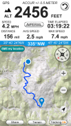
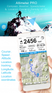
Get your elevation, climb rate and much more, wherever you are !
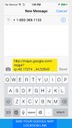
SMS your map location link
Your location link is very helpful in sometimes,such like when you are lost and you want ask your friends for a help. For this situation, you just need send your location link to she/he, and your friend can find you and your ways very easily in the building Maps (for map view in a web browser).
Features included
- Imperial and Metric unit settings.
- Altiude calibrate refresh button.
- GPS accuracy indicator.
- GPS distance accuracy indicator.
Track information
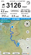
- Time elapsed.
- Distance.
- Average speed.
- Max speed.
- Altitude.
Tracking
- Speed tracking in mph or km/h based on MPH or KM/H mode.
- Distance tracking in miles or kilometers based on MPH or KM/H mode.
- Time tracking.
- Tracking location on map.
- Ability to turn tracking off/on.
- Longitude, latitude coordinates.
Map integration
- Satellite maps mode.
- Hybrid maps mode.
- Standard maps mode.
- Tracking location changes trajectory.
Compass
- Shows device real-time orientation to magnetic fields.
- Ability to switch between true and magnetic North.
- Location coordinates (longitude, latitude).
- Course
Share
- Start, end points, coordinates link email sending
让您的海拔,爬升率等等,无论你在哪里!
短信您的地图位置的链接
您的位置链接是有时非常有用,比如当你丢失,你要问你的朋友帮助等。对于这种情况,你只需要发送您的位置链接到他/她,和你的朋友可以找到你和你的方式很容易在建筑地图(在Web浏览器地图视图)。
包括产品特点
- 英制和公制单位设置。
- Altiude校准刷新按钮。
- GPS的精度指标。
- GPS距离的精度指标。
曲目信息
- 时间流逝。
- 距离。
- 平均速度。
- 最大速度。
- 高度。
跟踪
- 基于MPH或KM / H模式以mph或km / h的速度跟踪。
- 基于MPH或KM / H模式英里或公里距离跟踪。
- 实时跟踪。
- 在地图上跟踪位置。
- 再翻跟踪/关闭。
- 经度,纬度坐标。
地图整合
- 卫星地图模式。
- 混合地图模式。
- 标准地图模式。
- 跟踪位置的变化轨迹。
罗盘
- 显示设备实时定位磁场。
- 能够真正的和磁北之间切换。
- 位置坐标(经度,纬度)。
- 课程
分享
- 开始,终点坐标链接发送电子邮件


